Next week is the last week of classes, aaand then a week of finals :-/ But I am so ready for the Christmas break! I have been tossing the idea around with a couple friends about going hiking over break and I'm super excited. I would like to take a moment to say that I am entirely unprepared for such an endeavor, but try it I will. I have no idea where to begin with it and no idea where things will go; I'll pass on the information as I learn it, haha. :)
Don't let the cold weather get you down, use it!
G
Friday, December 3, 2010
Saturday, November 13, 2010
Sleeping Beauty - Not the Classic Story
I'm really starting to think that I may want to change these to Saturday posts - the weekdays are too full for me right now. :-/ I'm not sure, I'll definitely post if it changes for 'real,' haha.
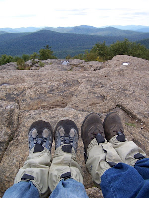
So I really should have posted this forever ago, but on 10/24 Robinson, Lauren and I headed up to Lake George. Our goal? To hike Sleeping Beauty Mt. ... without getting lost on the way there, or freezing to death, or getting caught in the rain, or staying overnight, or meeting terrifying animals, or ... you get the picture.
So around 9:30 I swung by Lauren's and picked both her and Robinson up, we hit the Northway (I-87), took exit 20 and got onto 149. But not in such a lovely order. We got to exit 20 OK, and then we missed the turn for 149 - so we went at least 12 miles out of the way. I've never been to Sleeping Beauty Mt., which is surprising because it's so close and it is such a nice hike. But since I've never been there, I had no idea where we were going or what kind of roads my Ford station wagon was going to be tackling.
We took a left off of 149 onto Buttermilk Falls Rd. and began an entertaining drive. The first part of the road was nice and paved - my car appreciated it. Suddenly we passed a sign saying 'Dirt Road Ahead,' and then there was the dirt road. OK, so it wasn't that bad. It was definitely better than a lot of the unpaved roads I've been on, but my car is old and I was terrified that something was going to break (it would be just my luck too).
The directions said to 'bear left onto Sly Pond Rd.' and then to 'continue on to Shelving Rock Rd.' These directions are technically correct, but I would argue that the descriptive terms of 'bear left' and 'continue on' should be switched. It definitely made us confused in the middle of nowhere. Eventually we found the little parking lot in Hog Town and we celebrated that my car had made it that far.

From this lot there is an access trail that, in good weather, you can drive down to a closer lot. Since it really wasn't 'in season' for hiking any more, the road was closed and we had to hike it. The path was easy going and was much more entertaining than some other access trails I've been on (I didn't do the length of the access path to the Avalanche Pass trail justice in that post), but, adding 1.6 miles to our trip (one way), it almost doubled the length of our hike.
Reaching Dacy Clearing, the second lot, we turned left and hopped a barrier to get onto the summit trail which is 1.8 miles one way. After a short ways up this trail, hikers come to the stone remnants of a building. None of having been here before, and all of us obviously entertained by the ruins, we stopped and climbed around them for a while. I forgot to mention above that when we started the hike, there was another hiker who started just behind us; he had legit trekking poles and, seeing as it's hunting season, was decked out in fluorescent orange. He had a much faster pace and passed us before we reached Dacy Clearing. When we stopped at the old foundation we must have given him at least a 15 minute lead on us.

At this point, it started to rain. Just a light sprinkle, but we still crossed our fingers and hoped for the best. The trail led us up a series of long switchbacks (when the trail doubles back and travels up the hill in a zigzag motion) and the rain progressed. We continued to slip up the mountain for what seemed like way more than 1.8 miles.
At one point the trail turned left and flattened out, we could see the gray sky and a trail marker was spotted that simply stated 'Summit 0.1 mi ↑.' At the same time, the hiker who had passed us on the access trail passed us again. We exchanged friendly 'hellos' and he went down another trail that would loop him back to Dacy Clearing by the longer route that passed Bumps Pond.
We proceeded the 0.1 miles, saying that it was perfect placement for that sign - we had been seriously starting to hate those 1.8 miles. The trees opened up on our left and the mountain opened up on our right. We were greeted to the summit by an insane view of misty mountains and a slap of cold wind in our faces. We scrambled around the rocky summit, took in the view, shot some pictures and hastily retreated to the protection of the trees.

After lunch and lots of marshmallows, the food of champions, we headed back down. We had initially planned to take the route to Bumps pond, but we were cold and tired and absolutely drenched. This direction was a lot of fun, I'm still not sure how Lauren made it back to the car without twisting an ankle, but thankfully she did. We signed out on the registry, piled back into the car and began the long journey down a wet dirt road.
When I got back home and got to look at my car, it was covered with mud. Now, I'm all for off-roading and I was very pleased to see that my car looked like it had just been through the swamp and back. I'm not entirely sure how it got so dirty - our max speed on the dirt rad was probably 30 - but it did. And I would have loved to have taken a picture, but my Dad cleaned it off before I could. I can only imagine what people on the Northway were thinking when they passed a dirt covered station wagon.
So there is the account of that hike. When you think of Sleeping Beauty, either the Mt. or the story, rain and marshmallows definitely do not come to mind. ;) I'm not sure what's in store for me next with the outdoors, but I will definitely keep you posted. The best I can say about anything is that it's looking like Mom and I might head up to Hadley again this fall.
Happy trekking,
G
Saturday, October 30, 2010
Hopping to Hadley
Yay for midterms eating my time!
But anyways, on the 16th, my mom and I headed up to Hadley Mt. again. I'm starting to think that whenever she and I go hiking, there is a strange pull from the house that never lets us leave. At 9:00 we stuffed the car with out ski poles, jackets, gaiters, lunches and gloves, then we climbed in and pulled out of the driveway. Oh wait - did I say gloves? No, we realized 100 ft down the road that we had both forgotten them; so we turned around, parked back in the driveway and went into the house to find our gloves. Five minutes later we were back in the car and 100 ft back down the road. My mom couldn't find her sunglasses, so we turned around and idled in the driveway while she went to look for them. She didn't even make it to the door before she felt them hooked into her back pocket. So, try three, we were 100 ft down the road and we were laughing so hard about how everyone must think we were crazy.
 So after our fabulous dance, we headed out to Hadley. Driving down Tower Rd. (the dirt road that the parking lot for the trail head is on) we passed some hunters and mom gave them quite a look, I'm just glad she didn't seem paranoid about getting shot for the rest of the trip! :)
We pulled into the parking lot around 10, and we proceeded to bundle up. I was rocking my gaiters, a three in one jacket, a ski pole and some fleece gloves (I had an extra windbreaker in my pack). My mom was rocking gaiters, a fleece pullover, a fleece vest, a heavy duty wind-resistant jacket, and two ski poles. We sprayed up to protect ourselves from the doom-bugs (aka: ticks) and we headed up the trail.
 It had rained a few days the week before and the weather kept telling the high elevation regions to 'watch for snow.' Fortunately we never saw any snow, but we sure saw a lot of water. The trail follows a stream up the mountain for most of the time and it was as high as we had ever seen it. In a few places where it crossed the trail, I got to try out my photography skills ... and my waterproof shoes. Everything went swell and my feet remained dry. :)
Quite a few people passed us as they were coming back down. As with every time I have hiked this trail, they reassure us that the summit is worth it. I guess it's a polite thing to say, but hey - don't we look like we hike often (with mom's fanny pack and my heavy jacket)? ;)
 One thing that I just couldn't get over during this hike was the leaves. Not just the colors, but more of the way that the trees changed. Leaf color was so dependent on elevation it was insane! One tree could have no leaves in it's top branches, A few red leaves below that, more yellow below that, and the lots of green near the ground. I know that temperature is a main factor in the leaves changing, but this was fabulous! Or at least I thought it was, being a biology major and all. ;) I hope the first picture and the picture above can do the idea some justice.
Almost at the summit there is a trail that heads off on the right that leads to an old ranger's cabin. We stopped there and had lunch (we bought subway on the way to the mountain) before venturing up to the cold summit. The wind was bitter and the bare rock offered no shelter. I debated climbing the fire tower, and decided to go halfway up. I was willing to subject myself to even harsher wind just for some pictures, but I wasn't going to be too crazy.


I'm not sure what way these photos are facing, I'll have to figure it out.
I must admit, we didn't stay on the summit long, and we were definitely glad to get back into the protection of the trees. But it was definitely a nice hike, and one that I needed. The outdoors is definitely something that calls to you. I'm not sure how to explain it if you don't know what I mean, but it's a call that you need to answer.
 So here's to me hopefully remembering to post this coming Friday and to tell you about my hike with Lauren and Robinson.
Peace,
G
But anyways, on the 16th, my mom and I headed up to Hadley Mt. again. I'm starting to think that whenever she and I go hiking, there is a strange pull from the house that never lets us leave. At 9:00 we stuffed the car with out ski poles, jackets, gaiters, lunches and gloves, then we climbed in and pulled out of the driveway. Oh wait - did I say gloves? No, we realized 100 ft down the road that we had both forgotten them; so we turned around, parked back in the driveway and went into the house to find our gloves. Five minutes later we were back in the car and 100 ft back down the road. My mom couldn't find her sunglasses, so we turned around and idled in the driveway while she went to look for them. She didn't even make it to the door before she felt them hooked into her back pocket. So, try three, we were 100 ft down the road and we were laughing so hard about how everyone must think we were crazy.
 So after our fabulous dance, we headed out to Hadley. Driving down Tower Rd. (the dirt road that the parking lot for the trail head is on) we passed some hunters and mom gave them quite a look, I'm just glad she didn't seem paranoid about getting shot for the rest of the trip! :)
We pulled into the parking lot around 10, and we proceeded to bundle up. I was rocking my gaiters, a three in one jacket, a ski pole and some fleece gloves (I had an extra windbreaker in my pack). My mom was rocking gaiters, a fleece pullover, a fleece vest, a heavy duty wind-resistant jacket, and two ski poles. We sprayed up to protect ourselves from the doom-bugs (aka: ticks) and we headed up the trail.
 It had rained a few days the week before and the weather kept telling the high elevation regions to 'watch for snow.' Fortunately we never saw any snow, but we sure saw a lot of water. The trail follows a stream up the mountain for most of the time and it was as high as we had ever seen it. In a few places where it crossed the trail, I got to try out my photography skills ... and my waterproof shoes. Everything went swell and my feet remained dry. :)
Quite a few people passed us as they were coming back down. As with every time I have hiked this trail, they reassure us that the summit is worth it. I guess it's a polite thing to say, but hey - don't we look like we hike often (with mom's fanny pack and my heavy jacket)? ;)
 One thing that I just couldn't get over during this hike was the leaves. Not just the colors, but more of the way that the trees changed. Leaf color was so dependent on elevation it was insane! One tree could have no leaves in it's top branches, A few red leaves below that, more yellow below that, and the lots of green near the ground. I know that temperature is a main factor in the leaves changing, but this was fabulous! Or at least I thought it was, being a biology major and all. ;) I hope the first picture and the picture above can do the idea some justice.
Almost at the summit there is a trail that heads off on the right that leads to an old ranger's cabin. We stopped there and had lunch (we bought subway on the way to the mountain) before venturing up to the cold summit. The wind was bitter and the bare rock offered no shelter. I debated climbing the fire tower, and decided to go halfway up. I was willing to subject myself to even harsher wind just for some pictures, but I wasn't going to be too crazy.


I must admit, we didn't stay on the summit long, and we were definitely glad to get back into the protection of the trees. But it was definitely a nice hike, and one that I needed. The outdoors is definitely something that calls to you. I'm not sure how to explain it if you don't know what I mean, but it's a call that you need to answer.
 So here's to me hopefully remembering to post this coming Friday and to tell you about my hike with Lauren and Robinson.
Peace,
G
Friday, October 15, 2010
I Must be a Hobbit
"For all Hobbits share a love of things that grow." This line is from The Lord of the Rings: Fellowship of the Ring (it's in the film, I'll have to check if the exact line is in the book).
My mom and I are heading up to Hadley Mt. tomorrow, given that the rain is polite; I told her that even if it does rain I'll still be happy to go. For the last week I have been stuck in the woods of Troy where the gray mountains can be scaled with the push of a button and the air is heavy with the stink of human. I need to smell the earth, I need to hear my footfalls on the root-laden dirt, and I need to feel the ache in my muscles and the excitement in my heart.
You don't realize how attached to something you have become until you don't have it.
G
Monday, October 11, 2010
Brain Cells
I think that as I learn more in college this year, I am losing the brain cells that make me remember things. :-/ Gah, so I'm posting this now in hopes that I will come back later today and update this into a real post.
Peace,
G
Friday, September 24, 2010
Fall Getaway
SOoooooooo, this weekend I am heading out to Seneca Lake for a retreat with Campus Crusade for Christ. I was hoping that there would be some nice geocaching out there, but there's nothing really within walking distance. :-/ Oh well.
Looking forward: I'm hiking Hadley Mt. again with my mom on the 16th, and it looks like I'll be heading out with Robinson and Lauren on the 24th. Yay!
Just keeping you posted,
G
Looking forward: I'm hiking Hadley Mt. again with my mom on the 16th, and it looks like I'll be heading out with Robinson and Lauren on the 24th. Yay!
Just keeping you posted,
G
Friday, September 17, 2010
Image Success!
Sorry about the delays with this post and the forgetfulness this past Friday.
Sooo, a little under a month ago (8/24) my mom took the day off to hike up Hadley Mt. with me before I left for school. I'm not sure what time we left, but we got to the mountain later in the day and the parking lot was more than half full.
 Let me give you a little background - my mom is paranoid of ticks. Why you ask? Because ticks = Lyme disease. So a few weeks before we headed out my mom went to Eastern Mountain Sports (EMS) and got us both some gaiters and some intense bug spray. (I'm going to take a quick moment to mention that I also bought a very nice Garmin Dakota 20 at EMS for about $100 off. EMS and I currently have a very nice, budding friendship). ;D
So we pulled off the dirt road and into the tiny parking lot just at the base of the trail head and proceeded to prepare for the hike ahead. We Velcroed and buckled on our gaiters, and sprayed down our pants with DEET bug spray; no ticks are gonna get on US! During this time two other groups pulled in, parked and headed up the trail.
We took a picture at the trail head, signed the log book and finally got started well into noontime. I mentioned in Into the Sky that I was now equipped with a hiking pole; this is just a simple, old ski pole that no longer has a mate. My dad took off the basket at the bottom and gave it to me to use (it's bright yellow so I can't loose it). Anyways, I gave this to my mom just after we passed the log because I didn't feel like carrying it, she griped a bit at first but was lenient to give it up later. :)
Now geocaching. My mom is NOT a fan of this, she is convinced that some evil-doer is going to lie in wait at a cache and kidnap me. OK, I admit, it could happen - but anyone who has gone geocaching knows that it most likely won't. So despite her dislike, I came prepared with my Garmin Dakota 20. There are five caches along the Hadley Mt. trail and I intended to find them. One of them I had already found on my last trip up Hadley Mt. with MD and I knew it would be a good example to calm my mom's fears. The first cache is a little ways up the trail and off to the right, unfortunately it was hidden nicely and I wasn't completely used to my new GPS yet so it took me a little while to find it (a fact my Mom was NOT happy with), but find it I did and we continued on up the trail.
 My mom is a much slower hiker than I had imagined, but it gave me time to crawl around on the rocks looking for caches. Next was the one I had found with MD and the third was a cache with three parts; you had to find the first cache which contained coordinates to the second which contained coordinates to the third. This multi-cach led you up the trail, stopping fabulous 'resting rocks' and ending just off the trail on the left at a beautiful spot I didn't even know existed! As my quest for these caches continued, my mom began to trust the geocaching pastime a little more. I can only hope that she will accept it more as time goes on.
During all this, we passed many people coming down the mountain; they all assured us with the fact that 'it's worth the hike.' We knew that, but thanked them anyways for their encouragement and plugged on. The day was beautiful, initially we had feared a little bit of rain, but we never got any. :) (MD and I joke that whenever we go hiking it's bad weather, and I'm starting to think it's true. The combination that we make must disturb the atmosphere because I haven't had that problem with anyone else).
 There was one more cache on the trail (and one at the summit): the 'Ranger Trail Cache,' it is just off the path on the right. There is the remnants of an old trail that used to be the ranger's trail, a pile of logs lie across the front of it so hikers don't travel down it unawares. I hopped the pile and headed to the coordinates while my mother waited on the trail near the logs (she continuously tells me that rule #1 is: don't leave the trail). This cache eluded me for the longest time, long enough that a group of maybe 6 women hiked up behind us and passed us. They stopped to talk with my mother and were thoroughly interested in what on earth I was doing in the woods. We tried to explain, they wished me luck and headed up the mountain. Unfortunately I couldn't find the stinking cache, so we hiked to the summit and concluded that I would find it on the way down.
The summit was fabulous! Visibility couldn't have been better and there was little to no wind! There is ALWAYS wind on top of Hadley Mt., which makes climbing the fire tower kind of scary at times. Today the tower didn't blow in the wind at all and I had to get a picture of me at the top. (When MD and I went up Hadley Mt. last time it was raining, foggy, cold and windy, and I was not a happy hiker at the top of the tower, so I had to show her I was alive at the top this time). We had our lunch of PBnJ, almonds, water and a flavorful juice box at the base of the tower.
 The group of women that had passed us were having their lunch a short ways off and a few of them seemed like avid hikers (my mom said they sounded like school teachers). They were still interested in this 'geocaching thing' and when I went off to look for the cache on the summit they asked me some more questions and watched me wander around looking for benchmarks (the one pictured is kind of boring-looking, but it marks the summit of Hadley Mt.).
Unfortunately I still wasn't completely used to the new GPS, my batteries were dying and I couldn't figure out how to set a heading with relation to the compass. So I gave up and sat back with my mom; Hadley Mt. isn't too far and I know I'll be back soon. A few moments later one of the women came up to me and asked if the cache was a Tupperware container; she had found the Hadley Mt. letterbox. I don't do letterboxing, but I know a bit about it and I explained it to them. It was really interesting to get to expalin these things to muggles (that's what geocacher's call people who don't know about the pastime) and I think that, since I gave them the geocaching website, they may actually check it out! :)

After a while that group left and my mom and I relaxed at the summit for a little longer before heading back down. When we did I was able to find the cache I had missed before (ugh, looking at something in one wrong angle can really screw things up) and I was definitely pleased with the GPS I had bought the day before.
On the way down we passed three groups heading up. The first was a guy and his dog with what looked like a lawn chair / daypack on his back, the second was a guy who said he takes this hike 2-3 times a week (impressive) and the third was a younger couple. We passed this last group about 15 minutes from the trail head and the girl asked us 'how much further to the top?' We responded with something to the effect of 'about a mile.' They continued on up Hadley Mt., but I'm not so sure that they made it to the summit, it was getting late and they already looked exhausted.
 We signed out of the log, tossed our gear into the car and headed to Panera for dinner. Let me tell you, there is nothing like some warm soup and a hearty sandwich after a day of hiking. :) Later, when we got home I handed my GPS to my dad and let him play around with it, and of course he found the application I needed to find the cache on the summit of Hadley Mt.. I was a little annoyed about that, but definitely happy that I now know how to set a new heading. (You'd think this would be easy, but it was hidden at the end of my menu under a strange title that I'm forgetting now).
So for the future: I am planning to hike Hadley Mt. again with my mom some time in October. Robinson, Lauren and I are trying to figure out a weekend that we can go somewhere, and I hope that more outdoors opportunities open up to me during school. Unfortunately MD is out of state for college and unless we make an elaborate feat of planning, we won't be able to do anything until Christmas break (considering she will go hiking in the snow).
Well that's that, I hope it was worth the wait. In Sticks and Stitches, I mentioned that I would only be posting when things happen, but I'm hoping to keep this thread going despite the lack of outdoor activities. I will find something to fill the empty Fridays for you. :)
 Any suggestions for easy, beginner winter hikes?
Peace,
G
Saturday, September 4, 2010
College
Hey guys,
Sorry about those last couple posts that I missed. I moved into my dorm last weekend and things are still getting settled. Since everything has been hectic and crazy here, I haven't had any time to post, yet alone blog. :-/
I still have to post about my hike up Hadley with my mom; but the memory card that I used doesn't even show the images when I plug it into my computer. So I'm not sure what's going on there. I used my mom's camera, so I'm hoping that when I go home either today or tomorrow that I can put the card back into the camera and them hook that up to my computer. I'm not sure what's going on with it, but I know that the camera registered us taking the pictures. So they have to be there somewhere, they are just hiding.
Once I find those pictures, I will post a review of our hike. I'd rather the pictures be with the post than separate. So look forward to seeing that this coming Friday (no promises though, technology hates me sometimes).
Sorry again for the delay, but sadly I am a student first and a hiker second.
G
Friday, August 20, 2010
Lost in Translation
So, on the 15th, MD and I had managed to move our schedules around for another hike. I had been wanting to take her to Avalanche Pass up in Keene Valley since we first headed up Hadley. I got directions from my Aunt a while ago, and finally go to put them to use.
The first problem we realized:
We had planned to leave around 9 so we would have all day to get there, mosey about, hike the trail and do anything else we felt like while still getting off the mountain before dark. Well, I slept in until 8:45 ish and proceeded to run around like a chicken with its head cut off trying to get ready in time. I texted MD to let her know and she responded with the fact that she had actually just woken up too. So we both took our time getting ready and then I headed over to get MD. Then we made a quick stop at Dunkin' Donuts (yay coolattas!) and didn't really get onto the highway until 10.
Second problem:
Ahhh weather; MD and I have come to the conclusion that whenever we are together the weather seems to get sad and the air cries. Since we go hiking whenever it fits our schedule, whatever weather we get is what we are stuck with, we can't reschedule. When I headed out the door Sunday morning, I strangely forgot to check on the weather and didn't bring any sort of coat with me.
And the third problem is the charm:
Since this trail is up in Keene (the High Peaks Region) and I only have trail guides for the Central Region and the West-Central Region of the Adirondacks, I didn't have that bit of security. I also generally keep a map in my car for perilous situations, unfortunately this map didn't stretch as far north as Keene.
So, onto the trip.
We hopped in the car with our doughnut and coolatta, headed to the highway and proceeded to exit 30 off of I-87. We took a left onto 73 and proceeded to wind through this beautiful thing called 'nature'. After a ways, we began to look for either Heart Lake Rd. or South Meadow Rd. (my Aunt wasn't sure about which one it was). We drove, and drove ... and drove. Anxious about the time and wanting to keep ahead of the clouds we had passed on the way up , we pulled over to check my map . After realizing our mistake, we decided to continue driving, after all 73 led past the road we were supposed to take and if we did miss it, we would be driving straight into Lake Placid where we could get a map and/or directions.
After a distance that was almost equal to the first that we spent on 73, we arrived in Lake Placid. There we purchased a Quickmaps Adirondack Quickmap. From this we were able to find where Avalanche Mt. was and then found the access road in relation to 73. A short distance back our of Lake Placid, we took a right onto Heart Lake Rd. (sneakily, this was also named 'Adirondack Loj Rd.' and we hadn't been looking for that).
Now the name Adirondack Loj Rd. is a dead giveaway for the Adirondack Loj to be down that road (I should have put two and two together and remembered that the Loj is at Heart Lake. Oh well) and I had been wanting to check the Loj out. So we drove to the end of the road, parked under the pretense of 'just looking around' and headed into the first building we saw. Now I'm not sure if this was the Loj, or just a gift shop: it looked kinda small, but we headed to the shop and I pulled the High Peaks Region trail guide off the shelf. I scanned the glossary for 'Avalanche' and figured out where we had to go.

Leaving the parking lot, we drove a short distance back up the road and took a right onto a dirt road that led to the 'Marcy Dam' trail (and others). Somehow I managed to guide my low riding station wagon down the extremely pocketed road and to a small lot at the end. We jumped out and headed for the trail. 'So I'd like to be back to the car before it gets dark, and since it's 1:20 right now, that means that wherever we are when it's 3:00, we turn around.' I told MD as we signed the trail register and passed the bear information.
MD and I divided this trail into three sections; lot to dam, dam to trail split, and trail split to Avalanche Lake. The first stretch was about 2 miles one way and was pretty much just an access path from the road to the wilderness. The fact that it was usually wide enough to drive a four-wheeler down kept distracting me, but it was a nice walk through the woods. This brought us right up to the bottom of Marcy Dam.
We took some pictures and wandered out onto the dam where I had a nice conversation with a man (his hiking buddy had already headed down the trail to the loj) from near Albany who had to head home for work (boo work conflicting with the Adirondacks). We talked about the weather and he said that it had been decent so far for them.

You can see from the view from the dam that is was rather foggy. A breeze was picking up and I wanted to reach the lake before 3. We then signed another trail register and headed to the left of the dam, past quite a number of campsites and a lean-to.
This began the second stretch of our hike which was about 1.8 miles one way. The gradient increased a bit, but nothing drastic, and it brought us along the side of a brook for quite a ways. This stretch was rather nice, but I remember talking with MD for most of it and not pulling out my camera.
A short ways from the third stretch we crossed a small bridge. Despite it being later than I would have liked, we paused to document a staged fight on the bridge with MD's camera and to mounain goat around the stream.
When we reached the beginning of the third stretch (about 1.2 miles one way) we paused to talk with a couple who was just descending. Again the weather was mentioned and our hopes raised, it hadn't rained yet and it was well into the day; if it was going to rain, we were already so into the hike that we would have pressed on despite it. This third stretch was definitely steeper than the second, but nowhere near as steep as what Lauren and I dealt with on Peaked Mt..

Fortunately for MD, this stretch was kept up rather well and there were lots of steps and walkboards for us. After ascending, the trail began to descend and through the trees, mountain walls could be seen rising up on either side of us. After a slight curve to the left with a decidedly downhill slant, an opening in the trees led us to the shores of Avalanche lake.

The left hand rock face turned out a little funky in the above image (SW), but it is just as high as the right hand one. The bottom image looks a bit more correct (NE). Despite the mist, the scene was great and MD informed me that this was one of her two favorite hike I had taken her on this summer (she has only been on three)

It is a It was now 4:10 - I had given up on my idea of turning around at 3 long ago. We took more photos and wandered around exploring (there's a boat up there that I really want to take out some time). After we posed, perched on top of a crag-like rock just out into the lake, for a picture with MD's camera (10 seconds are not nearly long enough) we headed back down to the car. Just as we took back to the trail, we met a man, toting a camera, who asked 'Please tell me the lake is nearby.' We responded with an assured 'yes,' and remembered only 2o minutes ago when we were in the same situation.

During the second stretch on our way down, there was a boy behind us. It kind of sketched us out, we asked if he wanted to pass (he had been behind us for a good 20 min and we had been giving him passing opportunities already) but he said that our pace was fine. We reached the dam, signed out of the register there and had a short snack sitting on the dam. The boy behind us crossed the dam and sat on the other side, a short while later two girls came down the trail and met up with him. Good to know that he was just faster than his party and wasn't stalking us (skeeetttccch!).
As we headed off the dam and onto the first (and final) stretch, a man came down the trail and signed out of the register. Since we were next to him we struck up some polite conversation and learned that he had just descended Mt. Marcy and was headed back to the Loj. He exclaimed that he was glad to be off of all those rocks, we told him we had just been up to Avalanche lake, but agreed with him none the less. When we parted with our new friend, MD informed me that she would have complained the whole time had we headed up Mt. Marcy. Baby steps MD, baby steps.
When we finally got back to the car (a good 10+ miles later), we turned to a print out of directions to a restaurant that MD's coworkers had suggested. Tail o' the Pup was just a ways through Lake Placid and we definitely enjoyed the hearty, flavorful BBQ meals. It was a great environment to relax in just after a hike, and then next time I'm up that way I may just have to stop by again.
So what's next for me? Well, I'm hiking Hadley Mt. again on the 24th, this time with my mother (I should have a GPS by then so get ready to hear about geocaching!). And on the 27th, I'm heading our somewhere with one of my good friends and her boyfriend, I'm not sure where to yet.
Also, I'm searching for people to take on winter hiking with me. I'm surprised at how many people are interested; I didn't think that many of my friends were up for such muscle aching work. But, I'll take what I have and hopefully they know what they are getting themselves into.
Anyone have a good daytrip that I could head out to on the 27th?
G
The first problem we realized:
We had planned to leave around 9 so we would have all day to get there, mosey about, hike the trail and do anything else we felt like while still getting off the mountain before dark. Well, I slept in until 8:45 ish and proceeded to run around like a chicken with its head cut off trying to get ready in time. I texted MD to let her know and she responded with the fact that she had actually just woken up too. So we both took our time getting ready and then I headed over to get MD. Then we made a quick stop at Dunkin' Donuts (yay coolattas!) and didn't really get onto the highway until 10.
Second problem:
Ahhh weather; MD and I have come to the conclusion that whenever we are together the weather seems to get sad and the air cries. Since we go hiking whenever it fits our schedule, whatever weather we get is what we are stuck with, we can't reschedule. When I headed out the door Sunday morning, I strangely forgot to check on the weather and didn't bring any sort of coat with me.
And the third problem is the charm:
Since this trail is up in Keene (the High Peaks Region) and I only have trail guides for the Central Region and the West-Central Region of the Adirondacks, I didn't have that bit of security. I also generally keep a map in my car for perilous situations, unfortunately this map didn't stretch as far north as Keene.
So, onto the trip.
We hopped in the car with our doughnut and coolatta, headed to the highway and proceeded to exit 30 off of I-87. We took a left onto 73 and proceeded to wind through this beautiful thing called 'nature'. After a ways, we began to look for either Heart Lake Rd. or South Meadow Rd. (my Aunt wasn't sure about which one it was). We drove, and drove ... and drove. Anxious about the time
After a distance that was almost equal to the first that we spent on 73, we arrived in Lake Placid. There we purchased a Quickmaps Adirondack Quickmap. From this we were able to find where Avalanche Mt. was and then found the access road in relation to 73. A short distance back our of Lake Placid, we took a right onto Heart Lake Rd. (sneakily, this was also named 'Adirondack Loj Rd.' and we hadn't been looking for that).
Now the name Adirondack Loj Rd. is a dead giveaway for the Adirondack Loj to be down that road (I should have put two and two together and remembered that the Loj is at Heart Lake. Oh well) and I had been wanting to check the Loj out. So we drove to the end of the road, parked under the pretense of 'just looking around' and headed into the first building we saw. Now I'm not sure if this was the Loj, or just a gift shop: it looked kinda small, but we headed to the shop and I pulled the High Peaks Region trail guide off the shelf. I scanned the glossary for 'Avalanche' and figured out where we had to go.

We took some pictures and wandered out onto the dam where I had a nice conversation with a man (his hiking buddy had already headed down the trail to the loj) from near Albany who had to head home for work (boo work conflicting with the Adirondacks). We talked about the weather

This began the second stretch of our hike which was about 1.8 miles one way. The gradient increased a bit, but nothing drastic, and it brought us along the side of a brook for quite a ways. This stretch was rather nice, but I remember talking with MD for most of it and not pulling out my camera.
A short ways from the third stretch we crossed a small bridge. Despite it being later than I would have liked, we paused to document a staged fight on the bridge with MD's camera and to mounain goat around the stream.
When we reached the beginning of the third stretch (about 1.2 miles one way) we paused to talk with a couple who was just descending. Again the weather was mentioned


The left hand rock face turned out a little funky in the above image (SW), but it is just as high as the right hand one. The bottom image looks a bit more correct (NE). Despite the mist, the scene was great and MD informed me that this was one of her two favorite hike I had taken her on this summer (she has only been on three)


As we headed off the dam and onto the first (and final) stretch, a man came down the trail and signed out of the register. Since we were next to him we struck up some polite conversation and learned that he had just descended Mt. Marcy and was headed back to the Loj. He exclaimed that he was glad to be off of all those rocks, we told him we had just been up to Avalanche lake, but agreed with him none the less. When we parted with our new friend, MD informed me that she would have complained the whole time had we headed up Mt. Marcy. Baby steps MD, baby steps.
When we finally got back to the car (a good 10+ miles later), we turned to a print out of directions to a restaurant that MD's coworkers had suggested. Tail o' the Pup was just a ways through Lake Placid and we definitely enjoyed the hearty, flavorful BBQ meals. It was a great environment to relax in just after a hike, and then next time I'm up that way I may just have to stop by again.
So what's next for me? Well, I'm hiking Hadley Mt. again on the 24th, this time with my mother (I should have a GPS by then so get ready to hear about geocaching!). And on the 27th, I'm heading our somewhere with one of my good friends and her boyfriend, I'm not sure where to yet.
Also, I'm searching for people to take on winter hiking with me. I'm surprised at how many people are interested; I didn't think that many of my friends were up for such muscle aching work. But, I'll take what I have and hopefully they know what they are getting themselves into.
Anyone have a good daytrip that I could head out to on the 27th?
G
Monday, August 16, 2010
Overdue Photos
I know it's not a Friday, but I wanted to post these before I forget to forever. These are the pictures I took with a disposable camera when Robinson and I went to Thirteenth Lake.

 Above is the view from Gilead Mt., it is really the only direction you can look out at (SW) but it is really very nice. The body of water you can see below is the South end of Thirteenth Lake, you can just make out the marshy area at the end.
This is a shot of the cross country ski trail we went down in hopes of finding the Old Farm Clearing. Despite the added mile it gave to our hike, and the increase of annoying bugs, it was actually a really interesting walk.
There was quite an interesting arrangement of flora and fauna, and it was just swampy enough in places to eat your shoes. I almost sank up to my ankle at one point when I made a careless assumption. :-/
 I wish that the vibrant greens transferred well into the photo. Anyways, next we went to William Blake Pond, and as I said, trees obstructed most of our views, so I couldn't really get a good shot of the whole pond. I think this picture actually show that well, lol.
I had another picture that I managed to get while leaning out over the pond, but the flash was on (on the disposable camera) and kind of highlighted the plant life to the left of the shot so the pond doesn't look too swell.
After this, we headed over to the Hooper Mine. As we reached the top of the trail, we were greeted by a large, orange obelisk directly in front of our path.

 It was really pretty cool to see the pockets of granite in the rock (like perfect little circles), and the rim of the mine just looms overhead.
Not to be outdone by the elements, Robinson and I mountain goated up a looser section just to the right of the giant outcrop on the left (the spot isn't really pictured here). We then proceeded to walk long the rim to the point. The top most part of the point, we are such thrill-seekers, no? ;)
So there you have them finally. I hope they were worth the wait.
G

 Above is the view from Gilead Mt., it is really the only direction you can look out at (SW) but it is really very nice. The body of water you can see below is the South end of Thirteenth Lake, you can just make out the marshy area at the end.
This is a shot of the cross country ski trail we went down in hopes of finding the Old Farm Clearing. Despite the added mile it gave to our hike, and the increase of annoying bugs, it was actually a really interesting walk.
There was quite an interesting arrangement of flora and fauna, and it was just swampy enough in places to eat your shoes. I almost sank up to my ankle at one point when I made a careless assumption. :-/
 I wish that the vibrant greens transferred well into the photo. Anyways, next we went to William Blake Pond, and as I said, trees obstructed most of our views, so I couldn't really get a good shot of the whole pond. I think this picture actually show that well, lol.
I had another picture that I managed to get while leaning out over the pond, but the flash was on (on the disposable camera) and kind of highlighted the plant life to the left of the shot so the pond doesn't look too swell.
After this, we headed over to the Hooper Mine. As we reached the top of the trail, we were greeted by a large, orange obelisk directly in front of our path.

In reference to the panoramic, the trail opens up on the right and was looking directly at the point on the far left. As with all pictures, this one does not do the scale justice and I suggest you go to check the mine out first hand.
 It was really pretty cool to see the pockets of granite in the rock (like perfect little circles), and the rim of the mine just looms overhead.
Not to be outdone by the elements, Robinson and I mountain goated up a looser section just to the right of the giant outcrop on the left (the spot isn't really pictured here). We then proceeded to walk long the rim to the point. The top most part of the point, we are such thrill-seekers, no? ;)
So there you have them finally. I hope they were worth the wait.
G
Saturday, August 14, 2010
Into the Sky!
Sorry for the fail on Friday, I was at Six Flags and totally didn't get home in time to post.
Last week was great, I didn't get to go hiking with Irene on the 9th, but I did get to keep my hike with Lauren on the 10th. We headed up to Thirteenth Lake and took the trail to Peaked Mt and Peaked Mt. Pond on the west side of the lake. Since I knew that there were supposed to be campsites there, we brought along our swimsuits in hopes of nice, refreshing water after the hike.
I would like to say that I can now get to these trails with my eyes closed. The Thirteenth Lake Rd. is very easy to find off of the Northway (I 87); if you can follow the signs to find Gore Mt. Ski area, then you can find Thirteenth Lake. After parking, we signed the trail register and wandered around looking for the trail.
Walking toward the lake from the parking lot there are two outhouses to the right (I wasn't expecting these, so it was a nice surprise that we were able to change into our swimsuits in privacy) and some campsites closer to the lake. Down on the left are some campsites and a nice, open beach for launching canoes and kayaks. After looking around we walked (what would be) straight ahead from the parking lot towards a small beach area for swimming, around there we took a right onto a footpath with red trail markers.
 This path followed the lakeshore in a SW direction, rising and dipping back down to the water. The weather was wonderful and I took a shot across the lake.
To give you a little perspective, the left of the two central rises in this picture is Gilead Mt.. Robinson and I hiked up the lefthand side to the top on the steeper right side. I kept looking for a view that would show us the rocks on top, but we never got far enough South.
After a ways we met up with Peaked Mt. Brook. There, the trail turned right and began to follow the river uphill. We met and passed an older couple looking at a map not too far up this part of the trail. On the left side of the trail was a bridge that led to the Hour Pond trail, I was unaware that this would be here and apparently so was this couple. They were looking at a topographic trail map (probably the same one I got from the ADK Central Region trail guide) where the intersecting trail was not pictured. They asked us if the trail ahead of them (not to the left) was to Peaked Mt. Pond and I responded with an assumed 'Yup.' as we smiled and passed them.
 The trail then proceeded to lace around three vleis. I read this in the trail guide as we came to them and we turned to the Glossary - 'Vlei: a low marshy area (pronounced "vly").' As the trail wrapped around the edge of the second vlei, we got adventurous and made our way out into the damp earth.
It was really rather entertaining to see the Peaked Mt. Brook cutting through the land like it was a warm knife to butter. The best thing was that you couldn't even tell the brook was there; looking at the vlei from a distance you would assume it was just a pretty swamp. But as we ventured out, we could hear the running water and would have walked right into the brook, had it been silent.
 There is also a good amount of beaver activity along this trail. There are quite a few little dams; but we didn't get to see any of the family members, let alone sit down to a dinner with them (I feel like reading Narnia, can you tell?).
We got our first glimpse of Peaked Mt. through the last clearing on the right. Dead trees reached up to the sky like a skeleton's fingers with the rocky summit of Peaked Mt. as a backdrop.
Shortly after this, we reached the pond (yay!). There was a family already there eating lunch, so we skirted to the left of them and had our own on a rock lying low to the water. Where the trail opens up is actually at a small inlet of the pond where the water is shallow and swampier (we made friends with a little water snake there). Following the trail to the right that leads to the summit of Peaked Mt. we found a trail leading to more campsites and a view of the whole pond. This panoramic is just of the inlet where we had our lunch; you can see Peaked Mt. on the right.

While we relaxed, the family headed out to the summit, the couple we passed came up to the pond (they said they weren't going to summit that day) and another couple made their way out of the trail. After lunch we followed the trail around the right side of the pond and we could immediately tell the gradient change. The trail to the pond was easy and relaxing while the hike to the summit was extremely steep. Fortunately it was less than a mile and it was well worth it.
As we reached the summit, the family was just beginning to descend (kudos to them for carrying a child up that steep climb) and a few minutes later the second couple from the pond reached the summit. They were kind enough to take our picture and chat for a while; in turn, we defined 'vlei' for them and pointed out below where the trail was.

This is the view facing more or less South, I don't think this really does the altitude much justice, but we really are a good way into the sky for such a short ascent. The large body of water is Peaked Mt. Pond, the little blip on the upper left of it is the inlet where we ate lunch. If you look to the left of that, you can see a kind of line that is formed at the base of the mountains. This is where Peaked Mt. Brook and the trail run; you can also see the three vleis (the middle one was the one we walked around in) and a small piece of Thirteenth Lake can be made out just past the largest vlei.
Unfortunately I didn't get to do any geocaching this trip, but I did stumble across some benchmarks that marked the peak. I found these while mountain goatin' and looking for views in different directions. I think this would be off to the Northeast.

We rested and snacked in the shade for a while then took to the decent (not without a few falls). On our way back we passed the couple that took our picture at the pond and again passed the family about halfway down the trail.
Despite the fact that it was 4:10 and Lauren wanted to be home by 5:00 (this would be an impossible feat), we changed into our swimsuits and waded into the beach back near the campsites. The ground was covered with small rocks that eventually became sand as you went deeper and the water was the perfect temperature. We swam around a bit, talking to the campers, then headed home for hearty dinners and heavy sleep.
I honestly don't think this hike could have been any better! The day wasn't too hot, the visibility was better than great, and the water was just a perfect ending. I'm going to have to look for more hikes to lakes.
Speaking of which, on Sunday MD and I are heading up to Avalanche Pass. I am now prepared with a hiking pole (yay for old ski poles) and I'll have to look into Avalanche Lake. I've been there before, but I can't remember much.
Any favorite Adirondack hikes you want to suggest?
Also, I will be getting up pictures from the Gilead Mt. hike soon. :)
G
Friday, August 6, 2010
Mountain Goatin'
A little late to post, but no one minds (because no one knows).
Robinson and I had originally planned to hit up Crane Mt. for the whole day on the 27th. Due to time constraints, we changed our destination to three short trails that are next to Thirteenth Lake in Warren County. There we were able to hike to the Balm of Gilead Mt., William Blake Pond, and the Hooper Mine.
Remember a while ago when I had nothing to post about so I gave you a bunch of links to have fun with (of course you do)? Well I mentioned the Adirondack Mountain Club's online store and the trail guides they sell; and I would like to take a brief moment to send love out to these trail guides. OK, these books are super tiny (5 x 7 in.) so they can fit right into a full day pack and they are loaded with information (including a great, topographic trail map). Hon the trail, we were able to point out and learn surrounding mountains, as well as historical snippets of the area; the guide definitely made the hike more interesting and enjoyable! :D
The first trail Robinson and I took to was the Balm of Gilead Mt; the hike to the top is only about a mile and, despite the steeper gradient, is very easy. Since it's only a mile to the top, one can assume that this isn't a higher mountain, but the view is stunning. We rounded a large boulder and were given a clear, 180 view of the south end of Thirteenth Lake and surrounding mountains (we were on the east side of the lake). The face of the summit was a rough cliff of orange-brown rock, here Robinson and I coined the term 'mountain goatin'' as we jumped south from rock to rock off the trail.
Next, in an attempt to find the Old Farm Clearing, we gallivanted down a cross country ski trail and learned that this area is really a little hub for a bunch of longer trails. Having learned that the clearing was further off than anticipated, we retraced our steps and took the trail to William Blake Pond. I think the short .8 mile hike to the pond was more exciting than actually reaching the pond. It was much more stagnant than expected (not gross, but not swim-able or wade-able either) and lots of branches hung down obscuring full views of the pond. Despite the momentary disappointment, there was lots of quiet shade, and it gave us a moment to relax and think about biology as we watched salamanders swim and classified lichen (I'm a bio major, so this is bound to happen more often than not).
Next we took the steeper, super short trail (.4 mi.) to Hooper Mine, an abandoned granite mine. Here we again practiced our mountain goatin' skills and scrambled through the loose rocks to a bright orange pinnacle on the left side of the horseshoe-shaped 'pit.' This gave a spectacular view of green earth, blue sky with the contrast of oxidized orange.
I brought a disposable camera with me (that binocular/camera thing didn't even turn on after I went through the trouble of finding AAA batteries!) , so I have to use the remaining 7 pictures then I can develop it and share the good ones! :)
On July 10th I hope to head back up to Thirteenth Lake with another friend, Lauren, and take the Peaked Mt. Pond trail that will lead us up the west side of the lake. Something may be happening on the 9th with a high school friend, Irene, but I'm not sure if it will go through. Also, my Mom and I (hopefully my Dad will come as well) are planning to head up to Hadley Mt. on the 24th. So, it looks like a full few weeks ahead of me, I will post again this next Friday.
My Dad has mentioned that there is camping at Thirteenth Lake but I haven't been able to check it out yet, does anyone know anything about that?
Keep trekkin'!
G
Friday, July 16, 2010
Broken Freedom
Hello, hello!
Broken:
First off, last time I posted I was over at Mental Dent's watching Star Wars. I would like to take a few moments to say that during a short-lived, epic battle over a mini lightsaber, my nose violently collided with MD's skull. Needless to say, my nose still hurts and there is a high possibility of the bridge being fractured (I bet MD feels great right now). However, since it looks fine, I have decided not to go to the doctor; they would really just tape it and tell me to be careful anyways.
Freedom:
Second up on the news reel, my second job ended today! Hopefully this means that a lot more time will be spent in the great outdoors! I already have plans to go up to Crane Mountain on the 27th with Robinson, a friend from high school :) and I am pretty psyched to get back outside! Goodbye staring at a computer monitor all day, I'm gonna see trees again!!
Hopefully, I will get outside before that. But whatever happens, I'll keep you updated.
Oh! My parents gave me this binocular/camera doohickey a while back. So I'll be getting batteries for it (AAA batteries = annoying) and seeing how it works.

Has anyone used anything like this before? Is it worth the batteries, or is it just a good idea that doesn't effectively translate into commercial use?
Comment and check back!
G
Comment and check back!
G
Friday, July 9, 2010
Battles with Stars and China
It seems like there will be no outdoors adventures for Mental Dent and me this week. :-/ I'm actually with MD right now; she says she really wants to go on Adirondack adventures; but tonight we are actually having a movie marathon (yay Star Wars!!).
MD says that she want's to be a Jedi.
So, instead of doing something productive outside, we are staying home and melting our brains with television! Sounds like a great swap to me, haha. ;) But really, I think that Star Wars is decent enough, it's a rather intelligent series.
So, since I'm away from my battle station (aka: my computer) and I'm borrowing MD's, I am rather unprepared for a good post today. :-/ But I feel that that's OK, especially since I've technically posted twice this week. But sitting here justifying myself while splitting my attention between the TV and MD is getting kind of confusing. I'm not sure that this post will make much sense at all. :P
Oh, and just to make the matters worse, I'm eating Chinese takeout! Oh dear, I shouldn't even be posting this, I feel like such a bad influence right now.
So, I will run away from the computer so only one monitor is melting my brain out of my ears.
MD says that she want's to be a Jedi.
G
I must have gone back and edited grammar on this post a million times by now; boy, you can tell I was distracted and half asleep when I wrote it! ;)
I must have gone back and edited grammar on this post a million times by now; boy, you can tell I was distracted and half asleep when I wrote it! ;)
Monday, July 5, 2010
Organization in Chaos
If you don't follow Sticks and Stitches, then you are unaware of my mind-blowing idea. Since this is a weekly post, I have decided to set a day for my posts (regardless of when my adventures happen to happen [haha, I love when the English language let's me do stuff like that]).
Since this blog is titled 'Finding Words for Life,' my weekly posts will be on Fridays. I know, I'm amazing and innovative. ;)
Now, since Saturday is a long way off, and my last post was on Monday, I'll give you a little something to run with.
Backpacker's August issue appeared in my mailbox late last week. :) In the Skills section it had a nifty little blurb about trail running. Now I know, the one thing everyone hates is staying in shape for something, (personally, I hate it; lifting is lame, and running on sidewalks is so not my forte). But trail running is something you can do on your own, no hiking buddy required, the scenery is generally great, and it keeps you in shape for hiking.
Now, of course there are suggested things, like getting trail-running shoes and heart rate monitors, but you can really just take to the dirt with whatever. Keep in mind that you are not running on pavement or a treadmill: you will move slower and will have to adjust your stride/footfall to the changing terrain. Like anything else, start it out slow and set easy goals until you get used to it.
Also, if you are setting out for a longer run (45+ min), you are going to want to take in 100 calories an hour. So, bring food (they suggest energy bars, but I tend to appreciate real food, even if I'm running) and water (yay for hydration)!
I'm not saying I'm an expert at trail running, by all means I'm not; I'm just passing on a few highlights of an article I enjoyed. There is definitely more information in there, so if you want me to relay any of it to you, just leave a comment for it! :D
Tune in on Friday!
G
Monday, June 28, 2010
Glad to Be Back
Boy, I didn't think I would ever say I was glad to be back on the internet! I'd like to apologize for dropping off the face of the earth; I was offered a second summer job (and as many of you know, college students can't really turn down a summer job offer). Unfortunately, this second job was a necessity and hiking is only a pastime. :-/ So, my life got put on hold, now that I've finally gotten settled into it, I have some time for other things: yay!
Since I had to put outdoorsy fun on the back burner, I don't have many exciting things to pass your way. But fortunately this week has started out well; I got to watch Toy Story 3 (throwback to my childhood, woot), a sac of baby spiders hatched on my ceiling (sounds gross, but it's kinda cool to watch them), and MD and I finally got to get outside.
Unfortunately, we were misinformed about the weather and decided to stay closer to home. But despite all the calls for thunderstorms, all we met was a hot, muggy sky in the Saratoga Battlefield. There is a great, one-way tour road through the park that we decided to bike down; it was definitely something we wouldn't have attempted, had we known more about its 10+ miles of hills and shadeless road, but I'm glad that we did tackle it.
We met up after church, pulled into the visitor's center some time after 2:00 and purchased our bike passes for the day. Then we took to our bikes with only a few granola bars and just one Gatorade each (light blue, as MD repeatedly specifies). We went to all of the stops on the tour, read almost all the signs and listened to all of the recordings of 'soldiers' and 'farmers' (we lovingly named these poor voice-acted bits as 'voices in a box'). I can't say that we really learned much of the history that we were presented with, but we were physically distracted and learning wasn't really our goal for the day.
All in all, it was a great trip, our muscles ached, our endorphins were high and we slept like rocks that night. I would love to recommend the park for biking, history, or just a casual walk (bring your dogs).
I'm not sure how soon I will be able to get back to the great outdoors again, but I will definitely give you something to run with weekly.
Comment, message me and use the links to follow MD!
G
(Haha, this was posted at 1:11, nice!)
Thursday, June 3, 2010
Useful info
Hey guys.
So, this week our plans again felt some confusion. Unfortunately MD was feeling rather ill, so instead of traveling an hour away and then 2 more hours up a mountain, we stayed close to home and made use of our local businesses. However, this local fun was completely unrelated to hiking and was very low key.
Now, rather than relaying our inactive outing to you, I decided you would be more entertained (seeing that this blog is related to Adirondack hiking) with some relative and useful information.
Here are a few of the links that I frequently use to set up our day hikes into the Adirondacks.
The Backpacker.com - is extremely useful for gear reviews. There is even a link of the home page that reviews the basics for the gear you will want.
Adirondack Mountain Club - is by far my favorite site. I use it to find trails I might be interested in. I will also take a moment to recommend that you check out their online store. You may think that buying printed books is a waste when you can just look online, but there is nothing more comforting than having a trail guide in your backpack just in case. (I highly recommend the Day Hikes guides: one for the Adirondacks, and one for the Catskills. There is also a nice book of dog hikes and if I still had a dog, this would be the first book I would buy.)
The Backpacker Magazine - is also available in print. It is extremely convenient to have, if even just to browse through. The site has a nifty skills page that offers articles from doing dishes and taking good photos during your outing, to navigation and weather prediction tips.
The ABC of Hiking - is another good site for product reviews. It also gives tips and tricks like The Backpacker.com and Magazine
Backpacking Lightweight - is pretty much what it says it is. In addition to hints for packing light, the site also sells some gear and offers basic knowledge and tips for hikers.
Lastly, this isn't a link so much as a little blurb of info. Obviously when you are looking to make a significant purchase (such as a backpack or heavy duty boots) you are going to want to compare prices. Don't just head straight to our good friends at eBay; do a little research. Check out items at some of the sites above, look for what you need as opposed to what you want (extra things may mean extra weight), then head out to REI and Dick's to check out the gear first hand. It is always better to see something for yourself than to just buy from a picture.
So that's it for this week, I hope these sites prove as useful to you as they have to me. I hope to come back next week after a day in the great outdoors! :D
G
Sunday, May 30, 2010
Starting Something?
I'm starting this for my own memory benefit, but if people want to follow it: enjoy. ;)
I have recently started hiking in the Adirondacks with a good friend of mine: MD. The Adirondacks take up a 6.1 million acre chunk of northeast New York; the Adirondack Mountain Club works to preserve a large section of this region for hiking and other recreational activities. With over 100 total peaks, there are the '46 high peaks' that reach an altitude of about 4,000 ft.
I would love to get to the point where I can call myself a '46er!' However, to get to the top, you must start at the bottom. And that is just what MD and I are doing. We have managed to schedule in one day trip a week since our summer started. We began with Hadley Mr. in Lake Luzerne and moved on to tackle the steeper-than-expected Prospect Mt. in Lake George.
MD is obviously a movie person and she brought her camcorder along on both trips. She quickly came out with a teaser of Tripp and Fall's outdoor adventures using the footage from out escapades at Hadley Mt. Unfortunately, the only day that week that we could schedule the trip, there was terrible fog and no visibility; despite that we had a great time and even did a little geocaching!
(This reminds me, I have also taken to geocaching this summer and will most likely incorporate it into my hikes as often as possible).
Prospect Mt. was a quick fix for our schedule. I had intended to surprise MD with the photo opportunities at Avalanche Pass in Keene Valley (this will be our next outing), but confusion ensued and that plan fell through the night before. The morning of our scheduled trip, we hastily decided on Prospect Mt. and headed out to Lake George. The hike was steep and tiring, but endorphins brought our feet to the summit where we enjoyed a view with great visibility and no fog!
As previously stated, Avalanche Pass is our destination for this week. I intend to post once a week, descriptions will be more in depth and will include directions to, and a summary of the trail.
If you've taken the time to read all this, I hope I've kept you entertained! :)
Thanks for your attention; comment, message me and tune in weekly!
G
Subscribe to:
Posts (Atom)